Lesson 1: Astronomical Geography: The World in Zones
Axis, Equator, and Day and Night
Note: This book has been modified for scheduling purposes and to modernize content.
The Earth is a sphere or globe. Its diameter is the distance through it, or a line passing from any point on its surface through the center to the opposite point. The diameter of the Earth is about 8,000 miles, and its circumference, or distance around it, is about 25,000 miles.
The Earth moves rapidly and constantly around the sun, from which it receives light and heat. It requires 365 1/4 days for the Earth to make one revolution around the sun, moving at the rate of over a million miles every day. If the Earth did not revolve around the sun, we would have no change of seasons.
The light of the sun covers one-half the Earth's surface at a time. On that side it is day, and on the opposite side, night.
The succession of day and night is caused by the rotation of the Earth on its axis.
The axis of the Earth is an imaginary line, on which it performs its daily rotation. The two points where the axis touches the surface are called the North and the South Pole.
Imaginary lines drawn on the Earth's surface from Pole to Pole are called Meridians, which always extend north and south. The circles which pass from east to west are the Equator and parallels of latitude. The Meridians are perpendicular to the Equator. Latitude and Longitude There are two kinds of Circles, great and small. A Great Circle divides the Earth into two equal parts, while a Small Circle divides it into two unequal parts.
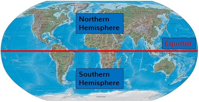
The Equator is a great circle which divides the Earth into Northern and Southern Hemispheres.
A Degree is a three hundred and sixtieth part of a circle. It varies in length, according to the size of the circle. Degrees are represented by (°).
The principal small circles are the two Tropics and two Polar Circles.
The Tropics are parallel with the Equator, and about 23 1/2° distant from it. They are the Tropic of Cancer and the Tropic of Capricorn.
The Polar Circles surround the Poles, and are 23 1/2° distant from them. The North Polar or Arctic Circle surrounds the North Pole, and the South Polar or Antarctic Circle surrounds the South Pole.
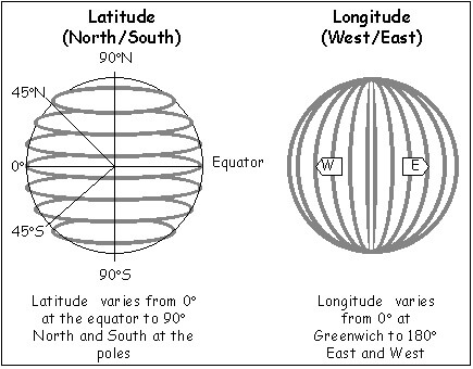
Latitude is distance north or south from the Equator. Places on the Equator have 0° latitude. The North and South Poles are in the greatest latitude—90°, or a quarter of a circle. The Zones Longitude is distance east or west from a certain meridian. We measure longitude from the meridian of Greenwich, also called the Prime Meridian, at 0° longitude. The 180° meridian opposite the Greenwich meridian called the International Date Line.
Latitude is marked on the right and left sides of maps. Longitude, on the upper and lower sides.
Zones are the five great belts into which the Earth's surface is divided by the Tropics and the Polar Circles. There are five zones: the Torrid, North and South Temperate, and North and South Frigid.
The Torrid Zone lies between the Tropics. It is 47° from north to south, and the Equator is in the middle of it.
The North Frigid Zone is between the North Pole and the Arctic Circle. In its center is the North Pole.
The South Frigid Zone is between the South Pole and the Antarctic circle.
The North Temperate Zone is between the Torrid and the North Frigid Zone.
The South Temperate Zone is between the Torrid and the South Frigid Zone. The Temperate Zones are each 43° wide.
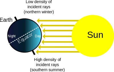
The Torrid Zone is hot throughout the year, because the sun shines more directly on that part of the Earth's surface. To every place in the Torrid Zone the sun is vertical (directly overhead or in the zenith) at certain times in the year. The Sun is never vertical to the inhabitants of the Frigid or Temperate Zones.
The Frigid Zones are cold throughout the year, because the sun shines indirectly or obliquely on those parts of the Earth's surface. Northern and Southern Hemispheres Within the Temperate Zones the heat is less than that of the Torrid, and the cold less than that of the Frigid Zones. Here are enjoyed four seasons—Spring, Summer, Autumn, and Winter.
The change of Seasons is caused by the revolution of the Earth around the Sun, and a uniform inclination of the Earth's axis to the plane of its orbit.
The Earth's orbit is the path or curved line in which it revolves around the Sun.
When the North Pole leans toward the Sun, it is summer in the Northern Hemisphere. Six months afterward, the Earth will be on the opposite side of the Sun, when the North Pole will lean away from the Sun, and the Northern Hemisphere will have winter. The seasons in the Southern Hemisphere are always the reverse of those in the Northern.
The Tropics mark the limits within which the inhabitants may have a vertical Sun. Tropic means turning.
The Polar Circles mark the limits within which the days and nights can be more than 24 hours long
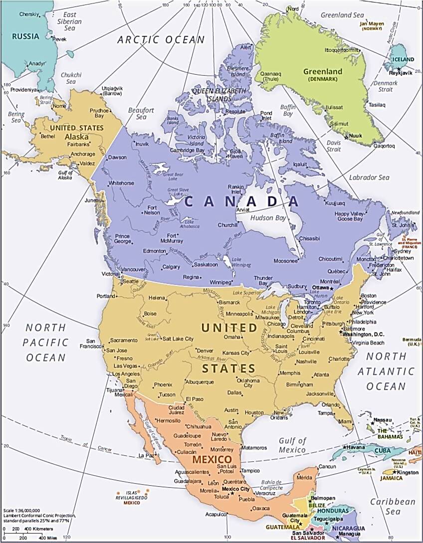
On the 21st of June, the Sun is above the horizon to places on the Arctic Circle, during the whole revolution of the Earth on its axis. That is, their daylight continues 24 hours. As you leave that circle and approach the North Pole, the length of the day increases, until you reach the North Pole, where daylight continues for six months, the Sun rising in March and setting in September. North America The cardinal points, or four directions, are north, east, south, and west. If you face the north, the east will be on your right hand, the west, on your left, and the south will be behind you. The north is shown by a mariner's compass, a box containing a needle which always points in that direction.
MAPWORK
Examine at the map of North America and answer the following questions:
Does the latitude increase or decrease moving from north to south?
Does the longitude increase or decrease moving from east to west?
What is at 0° latitude?
What is at 0° longitude?
All of the lines of latitude on the map are North (e.g. 40° N) - why is this the case?
Almost all of the lines of longitude on the map are West (e.g. 75° W) - why is this the case?
Point to the following places:
The Prime Meridian (0°)
The North Pole if the map were extended
The Equator if the map were extended
Trace the following lines of latitude and longitude:
Latitude: 20° N
Latitude: 40° N
Latitude: 80° N
Longitude: 0°
Longitude: 20° W
Longitude: 80° W
Longitude: 180° W
Estimate the latitudes and longitudes of the following locations.
Example - Philadelphia, Pennsylvania - Ans: Latitude: 40° N, Longitude: 75° W
 Comprehensive Geography
Comprehensive Geography
Comprehensive Geography


 About
About Curriculum
 Navigation